My Itinerary
You have no items in your itinerary.
Explore our website to add places and attractions to your own tailored itinerary.
Explore our website to add places and attractions to your own tailored itinerary.
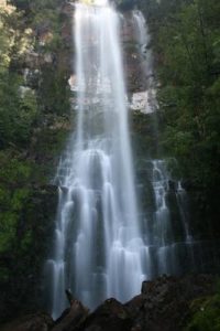
Situated on the eastern edge of the Southwest National Park, Adamsons Falls is an attractive waterfall accessed via a 6km return trail. Aside from occasionally muddy patches the track is easily followed in its entirety and should take just over 2 hours to complete.
The walk commenced with an easy stroll through regrowth forests. The track is wide but littered with boggy sections. Gradually, the trail begins to climb and you weave your way through charming established rainforests.
For the next 2km, the trail undulates through muddy forests before steepening at the final ascent to the waterfall. Once at the falls, a number of tiered sections can be accessed via short side trails. The most impressive view is offered at the top and under the falls themselves. As the ground is incredibly slippery, care should be taken when walking near the falls.
Return to the carpark via the same route.
A National Parks pass will be required to access the Southwest National Park. These can be obtained from the Huonville Parks Shop or online (https://passes.parks.tas.gov.au/).
Owned and managed by the Tasmanian Parks and Wildlife Service.
For bushwalk reviews visit the following sites: www.waterfallsoftasmania.com.au/waterfalls/adamsons_falls and www.alltrails.com.au/trails/australia/tasmania/adamsons-falls-track
Distance: 5.8km return
Suggested Time: Approx. 2 hours
Difficulty: Grade 3. Some bushwalking experience recommended. Generally distinct without major modification to the ground. Encounters with fallen debris and other obstacles are likely.
Facilities: There is a nearby cafe, toilets, picnic and barbeques and thermal swimming pool at Hastings Caves State Reserve (accessible by car).
Access: 2WD accessible, however may only be accessible by 4WD after rain.
Travel south on the Huon Highway to the township of Strathblane (7.5km south of Dover). At a junction 3.1km south of the Esperance River bridge, turn right onto Darcy Link Road. Then continue onto Creekton Road past the start of the Duckhole Lake walk.
After about 0.7km, the road splits into three. Take the central main track. After about a further 1.5km, an intersection to the right should be taken. This turn is signed, but the sign is visible when approaching from the opposite direction, rather than coming direct from Dover.
Drive along this road, avoiding the left turn, and up a steep hill to the end, where signs indicate the start of the track.
An alternative access is via the Hastings Caves Road and Chestermans Road. This route is only accessible with a 4WD vehicle. It is narrow with steep side slopes and can be slippery at times.
Tasmania’s remote areas are beautiful however weather and track conditions can change suddenly. Mobile reception in many of these areas can be limited or non existent. These tracks are not Council owned or maintained.
Be prepared for the walk or activity. Plan ahead, bring enough water, check the alerts, and make sure you are comfortable with the difficulty rating.
For more information, visit the following websites:
Leave No Trace is an internationally accepted way of minimising your impacts on the places we visit. Respect wildlife, be considerate of others, dispose of your waste properly.
Address
Adamsons Falls Track, Strathblane TAS 7109, AustraliaShare On