My Itinerary
You have no items in your itinerary.
Explore our website to add places and attractions to your own tailored itinerary.
Explore our website to add places and attractions to your own tailored itinerary.
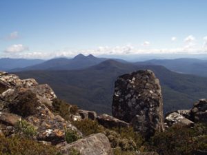
A long climb to the top of Adamsons Peak rewards with spectacular views in fine weather of the Southern Ranges.
A great hike for the more serious walker through tall forest and alpine moors reaching 1,226m at the summit. The trail challenges you with a mix of slippery boardwalks, overgrown paths, squelchy mud patches, and fallen trees, which slow your progress but add to the thrill of the hike. Despite the obstacles, the scenic views along the route make every step worthwhile.
As you navigate the steep uphill climb, be prepared for a demanding but ultimately gratifying experience. The trail’s rugged terrain demands careful navigation, so take your time and savour the natural beauty that surrounds you. The trail is great for hiking and walking, and it’s unlikely you’ll encounter many other people while exploring.
A National Parks pass will be required to access the Southwest National Park. These can be obtained from the Huonville Parks Shop or online (https://passes.parks.tas.gov.au/).
Owned and managed by the Tasmanian Parks and Wildlife Service.
For bushwalk reviews visit the following sites: www.alltrails.com/trail/australia/tasmania/adamsons-peak and www.travel.subodhad.com.au/adamsons-peak-tasmania-australia-34-reviews-map/
Note: This route although quite short, is not to be taken lightly and shouldn’t even be considered in winter. Warm clothes even on a sunny day should be atleast taken in a backpack. This area is subject to volatile weather and things can change incredibly quickly. The best times to visit this trail are October through March.
Distance: 15km return
Suggested Time: Atleast 8 hours
Difficulty: Grade 5 – Hard. Recommended for experienced bushwalkers only. This trail is challenging, slippery and steep, with plenty of obstacles like fallen trees and mud. The markers are generally good, but may take some looking around to find. Scrub bashing and narrow sections are common along the trail. Wearing gaiters is recommended due to the wet and muddy conditions.
Facilities: For closest facilities see ‘Local Facilities Map‘
Access: 2WD accessible.
Take the Huon Highway south to Dover. Continue south for about 4km until you reach the bridge over the Esperance River. Turn right just before this bridge onto Esperance River Road, following this for about 10km. When you reach a fork in the road, keep left onto Esperance Road that takes you down over the river.
After you have crossed, turn left again onto Peak Rivulet Road, ignoring all the spur roads that lead uphill to your right, and, staying on that road, you eventually arrive at the signed start to the walk (and a point where parking is easy).
Tasmania’s remote areas are beautiful however weather and track conditions can change suddenly. Mobile reception in many of these areas can be limited or non existent. These tracks are not Council owned or maintained.
Be prepared for the walk or activity. Plan ahead, bring enough water, check the alerts, and make sure you are comfortable with the difficulty rating.
For more information, visit the following websites:
Leave No Trace is an internationally accepted way of minimising your impacts on the places we visit. Respect wildlife, be considerate of others, dispose of your waste properly.
Address
Adamsons Peak Walk, Peak Rivulet Rd, Raminea TAS 7109, AustraliaShare On